
Martinsville and Henry and Patrick counties remain under a state drought emergency advisory despite recent rainfall, with all three localities entering October after recording precipitation deficits of roughly 8 inches during the first nine months of the year.
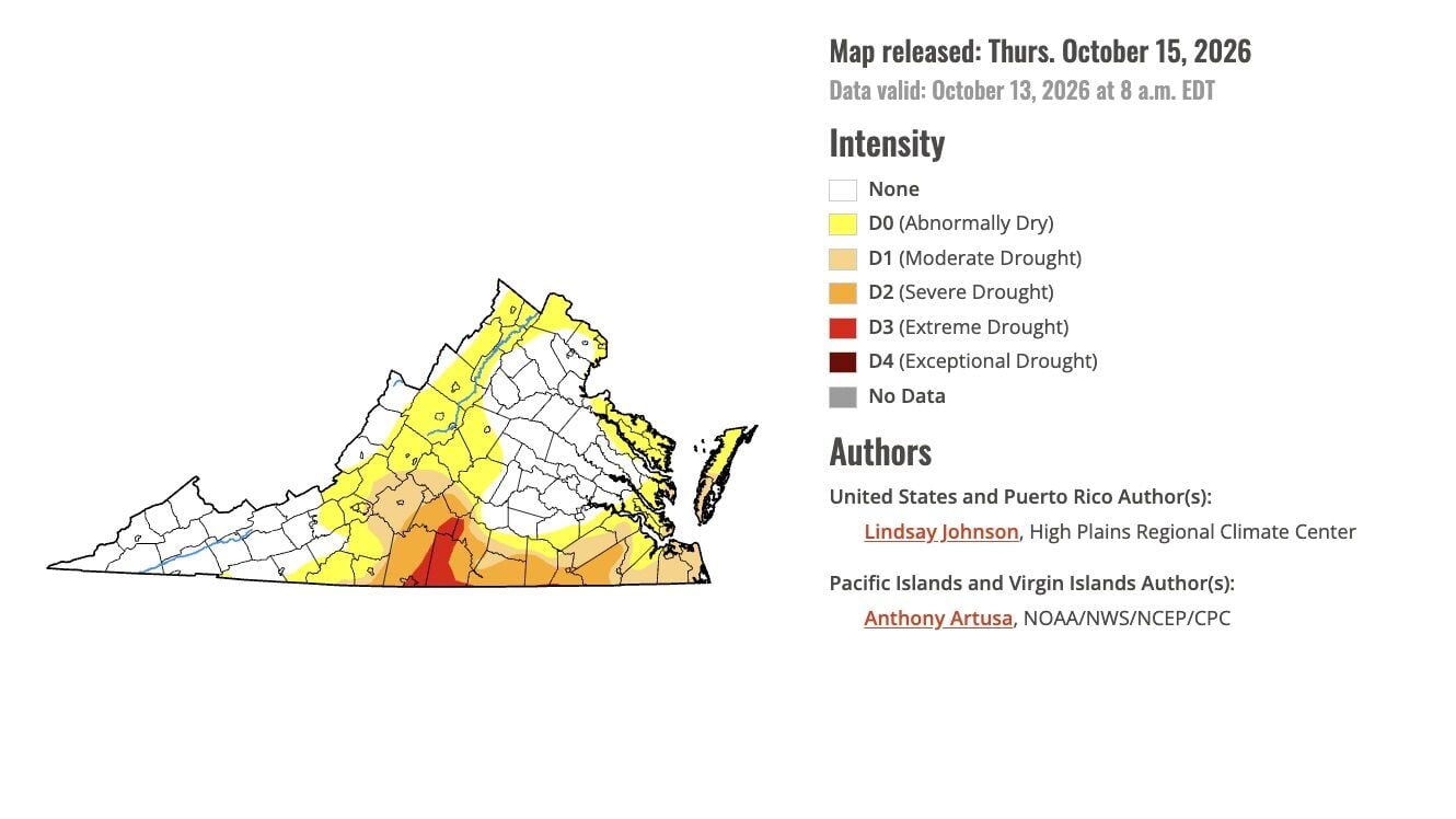
This map shows the latest drought data for Virginia, produced by the U.S. Drought Monitor.
The Virginia Department of Environmental Quality’s Oct. 8 update retained the emergency advisory for the Roanoke River drought evaluation region, which includes all three localities. The agency said rain had helped prevent worsening conditions, but the region had received less rainfall than other parts of Virginia.
The latest U.S. Drought Monitor, released Oct. 14 and reflecting conditions through Oct. 13, showed improvements in parts of Virginia. Its weekly assessment credited recent rainfall with easing short-term moisture deficits in portions of the New River and Roanoke valleys.
Roughly 58% of the local population is living in drought-affected areas. In Henry County, the estimated share was 59.6%, while Martinsville’s was 58.2%. Those figures reflect the population within mapped drought areas, not the percentage of land affected or the number of customers facing water restrictions.
Longer-term precipitation records illustrate the depth of the shortfall.
Henry County received 8.12 inches less precipitation than normal from January through September, making that period its 10th driest in 130 years of records, according to Drought.gov. September alone finished 1.86 inches below normal and ranked as the county’s 31st driest September.
Martinsville recorded an 8.02-inch deficit through January-through-September, also marking its 10th driest January-through-September period. The city’s September precipitation was 2.23 inches below normal, making it the 26th driest month in the historical record.
Patrick County’s precipitation deficit reached 6.8 inches during the same nine-month period, making it the 14th driest on record. September was 1.25 inches below normal and ranked 63rd driest. The figures show that the recent rainfall followed months of accumulated shortages across the area.
Virginia’s emergency advisory and the federal drought map are separate assessments. The state considers water-supply and hydrologic conditions, while the Drought Monitor maps drought intensity using categories ranging from moderate to exceptional. An improvement on the weekly map does not, by itself, announce a change in the state advisory.
In its Oct. 8 assessment, DEQ reported that streamflows remained below normal in the Roanoke River basin. Soil moisture had improved, but portions of the Blue Ridge and south-central Virginia remained drier than normal. Groundwater levels generally continued their seasonal decline, with recovery in some locations.
Smith Mountain Lake and John H. Kerr Reservoir remained well below average, the agency said. State officials continued encouraging water conservation.
The regional shortages are part of a longer statewide deficit. Virginia’s reporting period began on Oct. 1, 2025, and ended on Sept. 30, with an average precipitation shortfall of 8.6 inches, according to DEQ.


