
South Carolina is an area to watch for risk of tropical activity this fall despite a strengthening El Niño that typically curbs tropical formation in the Atlantic basin.
El Niño, and its counterpart La Niña, are the warm and cool phases of the earth’s climate determined by ocean temperatures in the equatorial Pacific.
Meteorologists have warned this El Niño could be one of the strongest climate events on record, and the strength could determine South Carolina’s coastal weather impacts through the rest of the year.
AccuWeather Long-Range Forecast Team Leader Paul Pastelok said this El Niño might show different impacts to South Carolina than in the past. Traditionally, El Niño events produce strong vertical wind shear making it difficult for hurricanes to develop in the Atlantic.
Pastelok marked September as a month that the wind shear might weaken, allowing better chances of tropical storm or hurricane formation. Another factor driving hurricane formation is warm ocean temperature, which is currently present in the Southwest Atlantic Ocean and Eastern Gulf.
“If anything can get going and make it to that area, it should survive and keep going,” he said.
When it comes to storms that could hit the Carolinas, Pastelok said some models are showing a shut-down of upper level highs (large domes of atmospheric pressure) over the Western Gulf, allowing for the Bermuda High (high-pressure system near Bermuda) to try to build back westward.
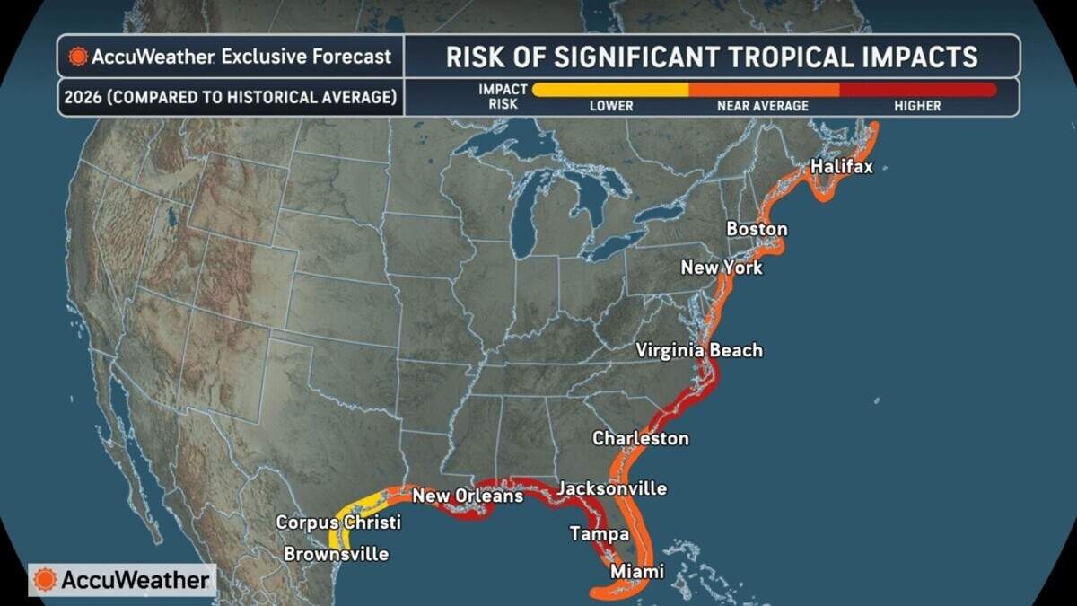 Risk of significant tropical impacts. Northeast South Carolina and North Carolina’s coast are an area to watch. AccuWeather
“A lot of storms like to go on the west side of that Bermuda High. The farther west it crosses, the higher chance it has of maybe hitting the southeast coast,” Pastelok said. “We’re seeing at times that this Bermuda High here in August, and then again in September can press a little farther west, and that puts South Carolina and North Carolina kind of in the prime area if anything does get together and develop in the South Atlantic.”
How will El Niño impact other weather along SC’s coast?
El Niño typically means a wetter fall and winter season for the southeast coast. South Carolina is forecasted to be right around average precipitation for a 90-day outlook; however, the timing of impacts is what may skew the average.
Pastelok said based on previous El Niño seasons the precipitation falls heavier from Texas to the Ohio Valley region in the first half of the season before it reaches the southeast coast, making it difficult for the southeast coast to see above average rainfall.
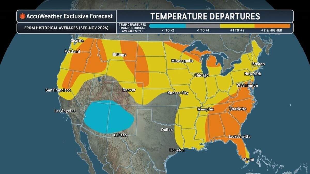 Temperature changes driven by El Niño compared to an average year. AccuWeather
“The only thing that would throw that off the edge would be a direct tropical hit,” he said.
Most of the wetter period will come after November through the winter, Pastelok said. Risk of flooding would likely only be if a tropical system came on land.
Less rainfall early on in fall also means higher than average temperatures along the southeast coast. That could materialize in a couple of ways, whether it be through daytime highs with more sunshine or nighttime lows when the humidity is higher.
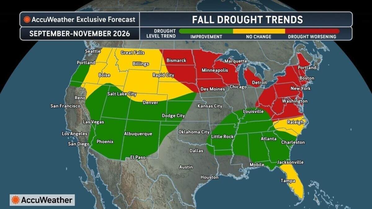 Fall drought trends across U.S. AccuWeather
The drought is likely to continue through fall but improve as rainfall totals increase later in the season. Fire weather could be a concern, but only short term during periods of high wind, especially across the interior sections of the state, Pastelok said.
It may take some time for the drought to resolve, but a tropical system could help decrease the severity.
El Niño can bring more severe weather to localized regions. This type of severe weather is usually limited to Florida, but it could reach into parts of southern South Carolina.
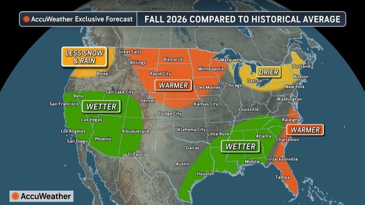 Fall 2026 weather patterns driven by El Niño compared to normal year. AccuWeather
What is making this El Niño so strong?
The strength of an El Niño or La Niña is determined by how much warmer or cooler the ocean temperature averages are in the equatorial Pacific.
An El Niño forms when sea temperatures are 0.5 degrees Celsius above average for several consecutive months.
The strengths range from weak (0.5 to 1 degrees Celsius above average), moderate (1 to 1.5 degrees), strong (1.5 to 2 degrees) and very strong (exceeding 2 degrees). A very strong El Niño is also widely accepted as a Super El Niño.
This year, meteorologists are expecting El Niño to reach the very strong threshold, making it one of the strongest climate events on record. There have only been four very strong El Niños since 1950, with 1982-1983 being the strongest at 2.2 degrees Celsius above average.
Pastelok said El Niños form when trade winds from South America to Hawaii are cut off.
“When you shut down those trades by certain circulation setup over the Pacific for a long duration of time, and the longer you do it, the warmer the waters continue to warm at the surface in the equatorial Pacific,” Pastelok said.
Certain waves, called Madden-Julian Oscillation waves that go across the world, provide warming at a deeper depth to keep the El Niño going.
If the oscillating waves were to shut down before September, there could be a regression, Pastelok said, however they are difficult to predict.
The Sun News
Nicole Blevins is the Coastal Climate Reporter for The Sun News. While attending Indiana University, Nicole covered breaking news and enterprise at the Indiana Daily Student. She previously interned with Mountain State Spotlight in Charleston, West Virginia before joining The Sun News team.
Get unlimited digital access
#ReadLocal
Try 1 month for $1


