
Almost 20,000 homes across Melbourne’s north-west and north-east have been identified as at risk of flooding, according to newly released flood maps from the city’s water authority.
About 7400 properties in Banyule City Council – which includes suburbs like Heidelberg, Ivanhoe and Rosanna – and a further 11,730 dwellings in Moonee Valley – including Essendon, Moonee Ponds and Ascot Vale – have been flagged as susceptible to stormwater flooding in the event of a significant rainfall event.
The draft maps released by Melbourne Water on Thursday morning are modelled on a “significant rainfall event” that has a 1 per cent chance of occurring in any given year. It is not intended to be a general representation of flooding in the area.
The new maps have been released as part of a two-year plan by Melbourne Water to update its flood modelling for each of the 38 metropolitan municipalities. They will replace older flood models, which were developed using outdated techniques.
In October last year, more than 60,000 properties across the inner-north councils of Darebin and Yarra were deemed to be flood-prone. Later that month, another 32,000 homes were flagged as at risk in Glen Eira and Merri-bek.
The Banyule and Moonee Valley maps are now accessible to the public through an online interactive tool, and will soon undergo a community consultation period. No planning controls have been changed in either council area yet.
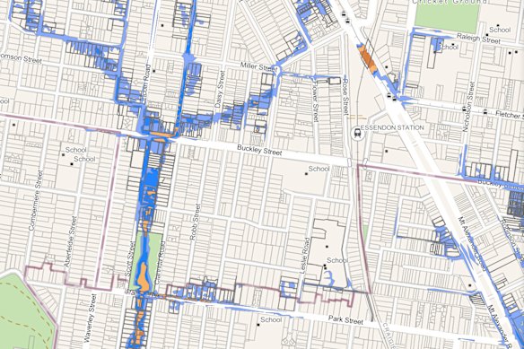
As part of its modelling, Melbourne Water assigns a hazard level to properties that are impacted as potentially at flood risk. The six rating levels indicate to residents how floodwaters might behave and the potential associated risk.
The lowest level (H1) indicates minimal flooding that is shallow and limited to low-lying areas. Meanwhile, the highest risk level (H6) warns of deep and fast-moving floodwater that is unsafe and may severely damage buildings.
In Banyule, 44 per cent of the impacted properties within the new draft map fall under the lowest-risk categories of H1 and H2. In Moonee Valley, 81 per cent have been assigned to the lowest two hazard risks, while seven per cent have been classified as H4 or above.
A statement from Melbourne Water assured Banyule and Moonee Valley residents that the majority of homes were not at risk of flooding. For those that are, it said the online maps provided clear information about how to be aware and stay prepared in the event of major rainfall.
Properties deemed at risk of flooding
Modelling is under a scenario for a major (one-in-100-year) flood
“We encourage every resident in Banyule and Moonee Valley to check their address,” Melbourne Water executive general manager of service futures Chris Brace said.
“For most people, the maps will confirm they are not at flood risk, or that their risk is lower than they might have expected. For those who are affected, we want to make sure they have clear and practical information about what that means for their property.
Moonee Valley mayor Dr Rose Iser encouraged residents who were impacted by the new draft map to book one of the Melbourne Water information sessions which are being held in July.
“I encourage everyone to check the maps. Most importantly, the maps tell council, other service providers and Melbourne Water where the work needs to be done to support our community and protect against flooding,” Iser said.
Banyule City Council mayor Alison Champion said in a statement earlier this month that the updated flood maps would help residents make informed decisions when it comes to their properties.
“Clear, reliable flood information helps our community plan … [and] will support effective planning and stronger preparedness,” Champion said.
The draft maps for Banyule and Moonee Valley will be finalised after the community feedback period closes on August 12.


